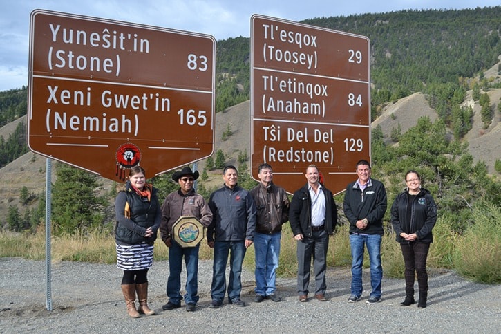
As part of the provincial government’s reconciliation efforts with the Tsilhqot’in Nation, distance signs will be installed on Highway 20, Taseko Lake Road, West Fraser Road and other area roads, indicating the names of each Tsilhqot’in community and distance in kilometres.
“I am pleased with our successful partnership with the Tsilhqot’in National Government to develop these local community highway signs,” said Transportation and Infrastructure Minister Todd Stone. “The signs are in both Tsilhqot’in and English, and honour the history and culture of the region’s original people.”
Tribal Chairman of the Tsilhqot’in National Government, Chief Joe Alphonse stated, “Since the acceptance of Title by the Supreme Court of Canada on June 26, 2014, and the signing of the Letter of Understanding with B.C. on Sept. 10, 2014, the Nation has been working with the Province to find unique ways of addressing ongoing issues – this requires patience.”
Chief Alphonse then went on to state, “Today marks the first time in history that our Tsilhqot’in communities will be listed on any provincial signs in British Columbia. The symbolic significance of this action cannot be overlooked. Relationship building with the Province is an ongoing process, but the hope is to build an enduring relationship based on trust and respect. The mileage signs act as an indication of the positive steps the Province is taking towards reconciliation.”
Members of the public traveling into Nemiah Valley or Tatlayoko Valley can also expect to see signs in the area advising them when they are approaching declared Tsilhqot’in Title Lands.
The new boundary signs show a map of the land that is subject to the declaration of Aboriginal title. The declared Tsilhqot’in Title Lands are situated east of Tatlayoko Lake around the north end of Chilko Lake—including the Nemiah Valley, Tsuniah Lake and along the Chilko River to its confluence with the Taseko River.
“The highway and boundary signs visibly represent the Province’s recognition of the Tsilhqot’in communities and title land and contribute to our joint goal of lasting reconciliation,” said Aboriginal Relations and Reconciliation Minister John Rustad. “We are building a strong relationship and actively working to finalize a comprehensive agreement that includes both economic and social priorities.”
On June 26, 2014, the Supreme Court of Canada recognized Aboriginal title held by the Tsilhqot’in Nation, including the right to exclusive use and occupation of the land, as well as the ability to determine the uses to which the land will be put.
The Province and the Tsilhqot’in National Government are currently developing a government-to-government agreement to achieve long term reconciliation with the Tsilhqot’in people.
Tsilhqot’in communities include Tl’esqox, Yunesit’in, Tl’etinqox, Tsi Del Del, Xeni Gwet’in and ʔEsdilagh.