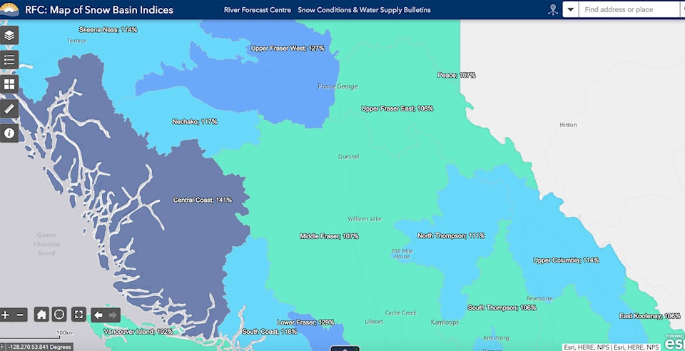
According to the BC River Forecast Centre’s March 1 Snow Survey and Water Supply Bulletin snow pack throughout British Columbia is above normal. The Central Coast is no exception, with snowpack in the region sitting at 41 percent above normal as opposed to 36 percent above normal at this time last year.
Record high snow surveys were measured in the Northwest, and Deadman River in the Lower Thompson. By early March, approximately 80 percent of the annual B.C. snow pack has typically accumulated.
Jonathan Boyd, a hydrologist with the River Forecast Centre, said that it’s not quite record breaking, but it is definitely something to watch.
“It’s definitely relatively quite high,” said Boyd. “This kind of snowpack is something we typically see about once in 10 years.”
Boyd said that while flooding remains a concern it’s not the typical time for flooding to hit the Bella Coola area, and flooding all depends on weather patterns in the spring.
“What we’d like to see is some dry weather, and an end to lots of precipitation for rest of the spring period,” said Boyd. “The favourable pattern is a pulsation of hot and cool, and historically that’s how weather works. There is an off and on of cool weather up and down, warm and cool, back and forth. When this happens the melt is gradual and not all at once.”
Boyd also pointed to the fact that is “La Niña” year, which typically brings cooler conditions. The centre said that La Niña conditions and seasonal forecasts from ECCC both indicate the likelihood of cooler conditions and possibly greater than normal precipitation over the next couple months.
This could lead to continued snow accumulation, delayed snow melt, and thus an increased risk for freshet related flooding. The risk of spring flooding is elevated due to the above normal snowpack across the entire province.
Analysis by the River Forecast Centre indicates that during historic La Niña years from the past 40 years, the snow pack increases an average of nine percentage points between March 1st to May 1st across the province. This means that if a basin was at 100 percent of normal on March 1st, it could measure 109 percent (on average) by May 1st. Areas in the Southern Interior tend to increase by 10 to 17 percentage points on average. Recent La Niña years have resulted in significant flooding, including 2017, 2012 and 2011.
However, the timing, magnitude and location of potential flooding will depend upon spring weather conditions.
Boyd also pointed out that there is a lack of snow measurement sites in the Central Coast area, the only location for the Valley is at the Burnt Bridge area, and that it’s a huge region to cover with limited data.
Approximately 80 percent of the annual B.C. snow pack has typically accumulated by early March. Snow pack throughout the province is above normal. The combination of a high March 1st snow pack, La Niña conditions that will persist through spring, and seasonal weather forecasts that predict cooler and wetter conditions for the province means an elevated risk for freshet-related flooding. Snow pack is also only one factor related to freshet flood risk.
Weather conditions from April through June determine the timing and rate of snow melt, and heavy rainfall events can exacerbate the situation. Flooding is possible in years with normal, or even below-normal, snow pack. Conversely, high snow pack does not typically lead to flooding without significant contributing weather during the snow melt season.
The next bulletin issued by the centre will be available in early April.