The Central Coast Regional District will receive $500,000 in disaster mitigation funding as part of a $6.5M investment in ten high-priority projects throughout the province. This investment builds on the $10.7 million in funding announced in February 2018 by the governments of B.C. and Canada to support 30 flood-mitigation projects throughout the province.
The CCRD has been awarded the funding to develop a flood risk assessment and to model several flood scenarios in the Bella Coola Valley. These studies are intended to help identify flood hazards, potential community impacts, and infrastructure vulnerabilities.
The announcement of this project aligns with the another flood mapping project funded by a $150,000 grant from the UBCM Community Emergency Preparedness Fund.
CCRD Chair Alison Sayers says the district will undertake a structured flood hazard and risk assessment of the Bella Coola river and its main tributaries, including Thorsen Creek, Snootli Creek, Nooklikonnik Creek and the Nusatsum River.
These assessments are intended to identify geographical areas that are at risk of flooding, their specific level of risk, and to help determine appropriate mitigation measures to reduce risk and liability during flood events.
It’s a large project that will require qualified experts numerous fields and includes work such as surveys, modelling, and the integration of climate change considerations.
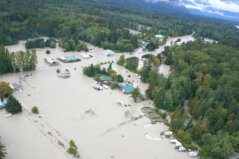
Flooding is perhaps the biggest threat to infrastructure and livelihood in the Valley. There have been 34 floods since the first recorded one in 1894, and Nuxalk oral history speaks of an epic disaster long before that, when all the villages were washed away, with only one canoe-load of survivors.
Numerous floods over the years have destroyed bridges, wiped out roads and prompted evacuations. But in recent memory one flood stands out above the rest: on September 26, 2010, the Bella Coola Airport recorded 309 mm of rain in 36 hours. The river came up four metres (13 feet) in 36 hours as floodwaters came rushing down from the plateau. It was impossible to cope.
Over 60 homes were evacuated and many were uninhabitable upon return. The highway was impassable in 12 sections and didn’t re-open for 17 days. Arrangements were made to have supplies brought in by barge and the community pulled together in one massive clean-up effort.
Since then there have been numerous high-water events, referendums on diking and countless discussions on the best way forward. Frustrated residents have watched as the water seems to creep ever closer more frequently and with greater ferocity, powerless to do anything more.
“From listening to residents and from December’s Town Hall held in Bella Coola, it’s clear to me that the river is unpredictably changing and people feel defenseless. The best way to be prepared for an emergency is to understand the risks in your local area. This funding will help the CCRD identify flood hazards, potential community impacts and infrastructure vulnerabilities,” said North Coast MLA and Parliamentary Secretary for Emergency Preparedness Jennifer Rice. “By knowing the potential impacts, the regional district can better plan for the future.”
It is part of the CCRD’s mandate to provide emergency planning and preparedness for the region, and Sayers said the Board of Directors has made emergency management its top strategic priority for 2018.
“It is the hope that this work will help to reduce the impact of disasters on the community and, at the same time, help to develop capacity and enhance resilience,” said Sayers. “The knowledge and strategic information gained through this project, and through the mapping work, will be used to educate and engage the Bella Coola Valley residents and business owners about existing and emerging flood hazards.”
Sayers said that the outcome of the project is intended to identify and provide risk-based prioritization of flood-related hazards in the Valley. Recommendations will then follow for flood mitigation measures for properties deemed at risk.
“A variety of recommendations for flood risk mitigation measures will be identified including identifying property and infrastructure at risk of flood damage, and to develop policy options that can minimize the hazard, exposure, or vulnerability risk,” explained Sayers. “This knowledge will be used in the development of land use policies, bylaw adjustments, early warning systems, emergency response plans, education and outreach, and mitigation planning.”
Work is to begin this year and carry on for two years, with an estimated completion date of 2020.